 To explore the validity and possibility of extending PATH service to Newark Liberty International (EWR) Airport, WT has developed methodologies to forecast travel market for the region and highlighted the mode shares along the corridor. Approaches and methods were developed for four types of travel segments respectively.
- For the air travelers market, the access mode and airport choice models were developed from newly collected Stated Preference (SP) and Revealed Preference (RP) survey data in the study corridor, as well as from information from existing travel demand models and other local sources, and from previously conducted SP/RP surveys;
- For the airport employees, the employee access mode choices were asserted based on information from existing travel demand models;
- For non-airport traveler’s markets, the mode choices were adapted from existing travel demand models;
- For new trips, WT made use of the generalized costs computed as part of the airport choice and mode choice models to estimate how many new trips may be generated by the improved access. The TOD-induced demand was estimated using an existing transportation demand model with updated land use information.

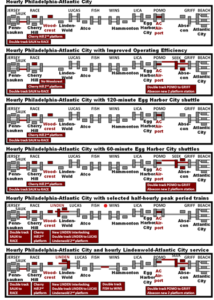
 This project is charged to provide a complete “library” of infrastructure/operating scenarios, coupled with associated capital costs and identification of environmental issues. The “library” is to support the establishment of a strategic investment strategy, which can be endorsed by NJ TRANSIT, the DRPA and other stakeholders. Ultimately, a cost-benefit graph was produced, with “benefit” reflecting a blend of capacity, travel time and reliability improvements, and “cost” reflecting life cycle costs, including both capital and operating expenses.